The Pondoland-Ugu Sandstone Coastal Sourveld is a vegetation type found in South Africa within the Indian Ocean Coastal Belt Biome. This vegetation type is characterised by grassland species, with some scattered low shrubs and small trees. There are about 100 important medicinal plant species that occur in the Pondoland-Ugu Sandstone Coastal Sourveld.
Distribution

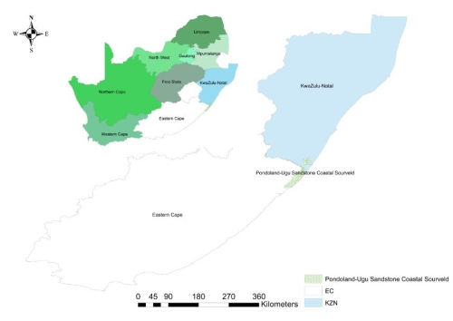
The Pondoland-Ugu Sandstone Coastal Belt is found in both KwaZulu Natal and Eastern Cape provinces; it is situated along the northern coast of the Eastern Cape and the southern coast of KwaZulu-Natal. The vegetation type starts from the elevated coastal sandstone plateaus near Port St Johns (Eastern Cape) to Port Shepstone (KwaZulu Natal); this also includes the Sourveld of the Oribi Gorge. Altitudes in this region range from 0 – 600m.
Vegetation and landscape
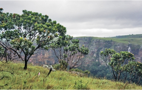
The area is characterized by coastal peneplains and gentle undulating hills with very flat table lands and very steep river gorges. These different landscape features are usually rich in grassland species with a variety of different scattered small shrubs and small trees. The area also comprises of rocky outcrops and krantzes. Sea cliffs can also be observed in the area.

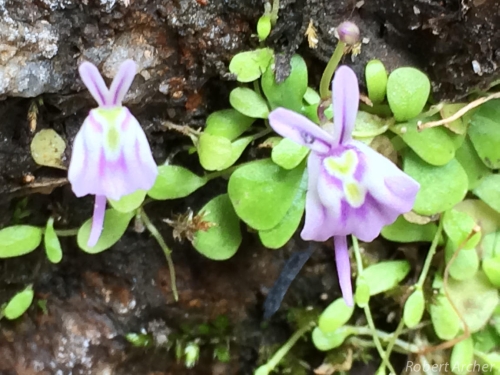
A suite of local endemic and biogeographically important taxa, such as Utricularia sandersonii, Kniphofia rooperi, Podalyria velutina, Watsonia bachmannii and Watsonia pondoensis, is linked to hygromorphic soils and are supported by the slight depressions on the coastal plateau and rock pools on rocky outcrops.
Geology and Soil
In terms of geology and soil, the Pondoland-Ugu Sandstone Coastal Sourveld is limited by its geology which comprises of hard white, coarse grained siliceous quartz arenites (sandstone) of the Msikaba Formation of the Devonian Period.

The geology of the area gives rise to shallow, skeletal acidic sandy soils which is also poor in nutrients. There is a geological link between the sourvelds of South Africa; the link between these sourvelds is because of the sandstone geology of the Pondoland. Pondoland forms the lowest step along a staircase of nutrient-poor geologies, comprising further the early Palaeozoic Natal Sandstones of the KwaZulu-Natal Midlands and the Late Triassic Clarens sandstones of the Drakensberg (Van Wyk, 1994).
Climate
The climate of the Pondoland–Ugu Sandstone Coastal Sourveld differs with the seasons with mean maximum monthly temperatures being 32°C in summer and the mean minimum monthly temperatures in winter being 5.8°C. In terms of rainfall, the area experiences heavy rains in summer and slight showers during the winter season.
Endemic Taxa
Endemism is the ecological state of a species being unique to a well-defined geographic location, such as an island, nation, country or other defined zone, or habitat type. Organisms that are indigenous to a place are not endemic to it if they are also found elsewhere.
The Pondoland-Ugu Sandstone Coastal Sourveld has a number of endemic plant species, such as the Tephrosia pondoensis (Pondo poison pea) a rare species that is listed as Endangered by the Red List of South African Plants. There are also a number of endemic herbs within the vegetation type some of these are a Least Concern such as the Selago peduncularis (Raimondo et al.), and some are Near Threatened such as the Lotononis bachmanniana (Raimondo et al.). Other endemic herbs include Geranium sparsiflorum, Senecio erubescens and Eriosema umtamvunense.

Geophytic species (plants that have an underground storage organ) include: Brachystelma australe, Brachystelma kerzneri, Watsonia inclinata, Watsonia mtamvunae.
Geoxylic suffrutices (these are plants which have enlarged and woody structures beneath the surface of the ground), according to Mucina et al. (2006) there is only one endemic, Searsia acocksii, which is listed as Near Threatened by the Red List of South African Plants.
Low shrubs endemic to the vegetation type include: Leucadendron spissifolium subsp. natalense, Leucadendron spissifolium subsp. oribinum, Anthospermum streyi, Erica abbottii, Erica cubica var. natalensis, Eriosema dregei, Eriosema latifolium, Eriosema luteopetalum, Euryops leiocarpus, Gnidia triplinervis, Leucadendron pondoense, Leucospermum innovans, Raspalia trigyna, Struthiola pondoensis, Syncolostemon ramulosus and Tephrosia bachmannii.
Important taxa found in the Pondoland-Ugu Sandstone Coastal Sourveld include:
Graminoids (refers to herbaceous plants without grass like features or morphology) these include (Cymbopogon nardus, Themeda triandra), important herbs (Chaetacanthus burchellii, Cyanotis speciosa, which is dominant and known as Umagoswana in one of the native languages), geophytic herbs (e.g. Brachystelma tenellum, Eriospermum mackenii), low shrubs (e.g. Gnidia nodiflora, Polygala hottentotta), small trees (Euryops brevipapposus, Syzygium cordatum) and semiparasitic shrubs (e.g. Thesium acutissimum, Thesium cupressoides).
Biogeographically Important Taxa
The Pondoland-Ugu Sandstone Coastal Sourveld has a number of biographically important taxa which comprises of herbs, shrubs, and trees. These different species are distributed throughout the vegetation unit from the coastal area to the north to the southern regions of the vegetation unit.
Biographically important taxa include geoxylic suffrutices (e.g. Gymnosporia vanwykii), graminoids (e.g. Loudetia simplex, Calopsis paniculata), herbs (e.g. Helichrysum auriceps, Helichrysum natalitium), geophytic herbs (e.g. Stenoglottis woodii, Asclepias patens), low shrubs (e.g. Senecio medley-woodii, Gnidia woodii), geoxylic suffrutescent forbs (e.g. Eriosemopsis subanisophylla) and small trees (e.g. Faurea saligna, Encephalartos caffer).
Conservation
The conservation status of the Pondoland-Ugu Sandstone Coastal Sourveld is classified as vulnerable with a conservation target of 25%, only 7% is statutorily conserved in the Mkambati Wildlife Reserve, Marine Sanctuary and Umtamvuna, Mbumbazi and Ogibi Gorge Nature Reserves. About 29% transformed for cultivation and plantations or by urban sprawl. In the Eastern Cape the land use is mostly subsistence farming. Erosion is low.

Vegetation Type Attributes:
Distribution: Southern coast of KwaZulu-Natal to northern coast of the Eastern Cape
Area: 1289.620243 km2
Climate: Sub-tropical
Land-use: Agriculture, Conservation, Plantations.
Author:
Qabaqaba Mcebisi
Acknowledgements:
Images sourced from L. Mucina. Lynette Clennell, iSpot southern Africa and Eastern Cape Parks and Tourism Agency.
References:
Mucina, L., Scott-Shaw, C.R., Rutherford, M.C., Camp, K.G.T., Matthews, W.S., Powrie, L.W. & Hoare, D.B. 2006. Indian Ocean Coastal Belt. In: Mucina, L. & Rutherford, M.C. (eds), The vegetation of South Africa, Lesotho and Swaziland: 568-583. SANBI, Pretoria
Raimondo, D., von Staden, L., Foden, W., Victor, J.E., Helme, N.A., Turner, R.C., Kamundi, D.A. and Manyama, P.A. 2009. Red List of South African Plants. Strelitzia, 25. South African National Biodiversity Institute, Pretoria
South African National Biodiversity Institute (2006- ). The Vegetation Map of South Africa, Lesotho and Swaziland, Mucina, L., Rutherford, M.C. and Powrie, L.W. (Editors), Online, http://bgis.sanbi.org/SpatialDataset/Detail/18, Version 2012.
Van Wyk, A.E., 1994. Maputaland-Pondoland region. Centres of plant diversity: a guide and strategy for their conservation, 1, pp.227-235.
von Staden, L. & Abbott, A.T.D. 2007. Tephrosia pondoensis (Codd) Schrire. National Assessment: Red List of South African Plants version 2017.1. Accessed on 2017/04/19
von Staden, L. & Abbott, A.T.D. 2007. Searsia acocksii (Moffett) Moffett. National Assessment: Red List of South African Plants version 2017.1. Accessed on 2017/04/19


